I’d need an adequate printer and scanner.
3 Likes
What about using a standard vector drawing program?
3 Likes
I don’t have the coordination to line things up to each other, if they don’t snap to the same grid. I need them to snap to the same grid to make rivers, rail lines, etc. intersect, to make circles around a city center on that city, etc. And it drives me nuts when they don’t line up.
I know how to use LibreOffice Draw, but it’s easy for points to get misaligned from the grid, and it’s a lot of fine work to replace them with new points which are aligned to it.
I tried Inkscape. I don’t know how to use it, I can’t see the interface because it’s too fucking small, I can’t navigate the preferences without migraines, I can’t read the manuals, etc.
5 Likes
Do you use a mouse or some type of stylus-type of device?
2 Likes
For the printer you could make a batch order somewhere, though if you only need something of the size of regular printer paper you could get it printed at the library for a reasonable price ![]() and for the scanner hopefully the library also has one, but if not a print shop would have a large format printer.
and for the scanner hopefully the library also has one, but if not a print shop would have a large format printer.
Alternatively if you have a friend with an office job they’'re def gunna have a printer and scanner ![]()
5 Likes


What a time to be alive…
15 Likes
13 Likes
but i don’t like moon pies!
9 Likes
14 Likes
It took me a while, but here it is:
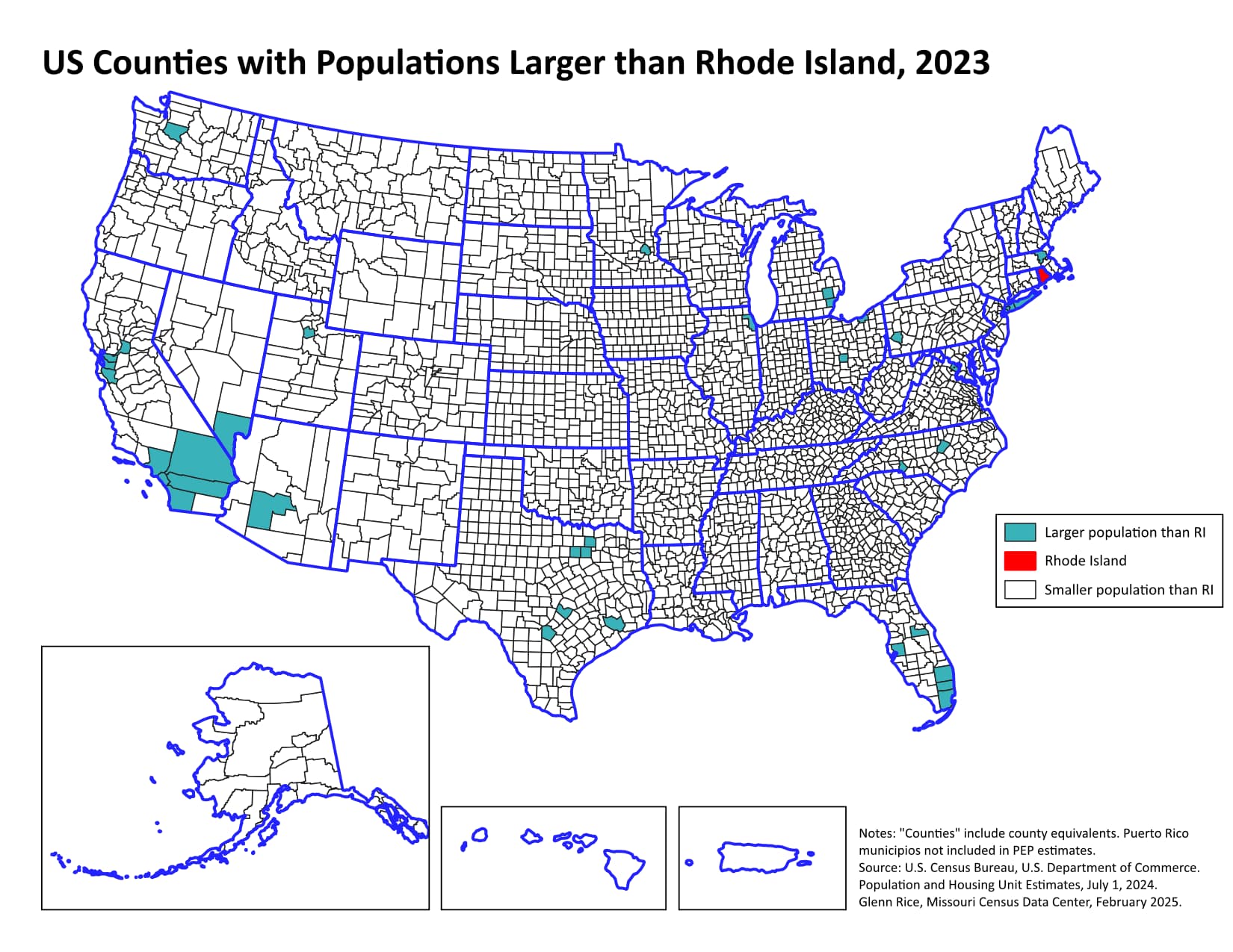
There aren’t many! The population estimate for RI as of July 1, 2023 is 1,095,962. That’s more governance than most counties can handle.
Next up, a better comparison of county vs. state population.
14 Likes
This is definitely useful, though. I could see someone using the first map to question why Rhode Island gets 3 electoral votes; this map provides a useful rejoinder in the “land doesn’t vote” line of argument.
9 Likes
Wow, I thought Montgomery Co. (MD) might be that big, but not quite. I was wondering about Fairfax Co. (VA) - & it is that big, it’s just hard (for me) to see it on the map.
7 Likes
Picking the smallest state by population (Wyoming, with 584,057 souls) doesn’t change the outcome much:
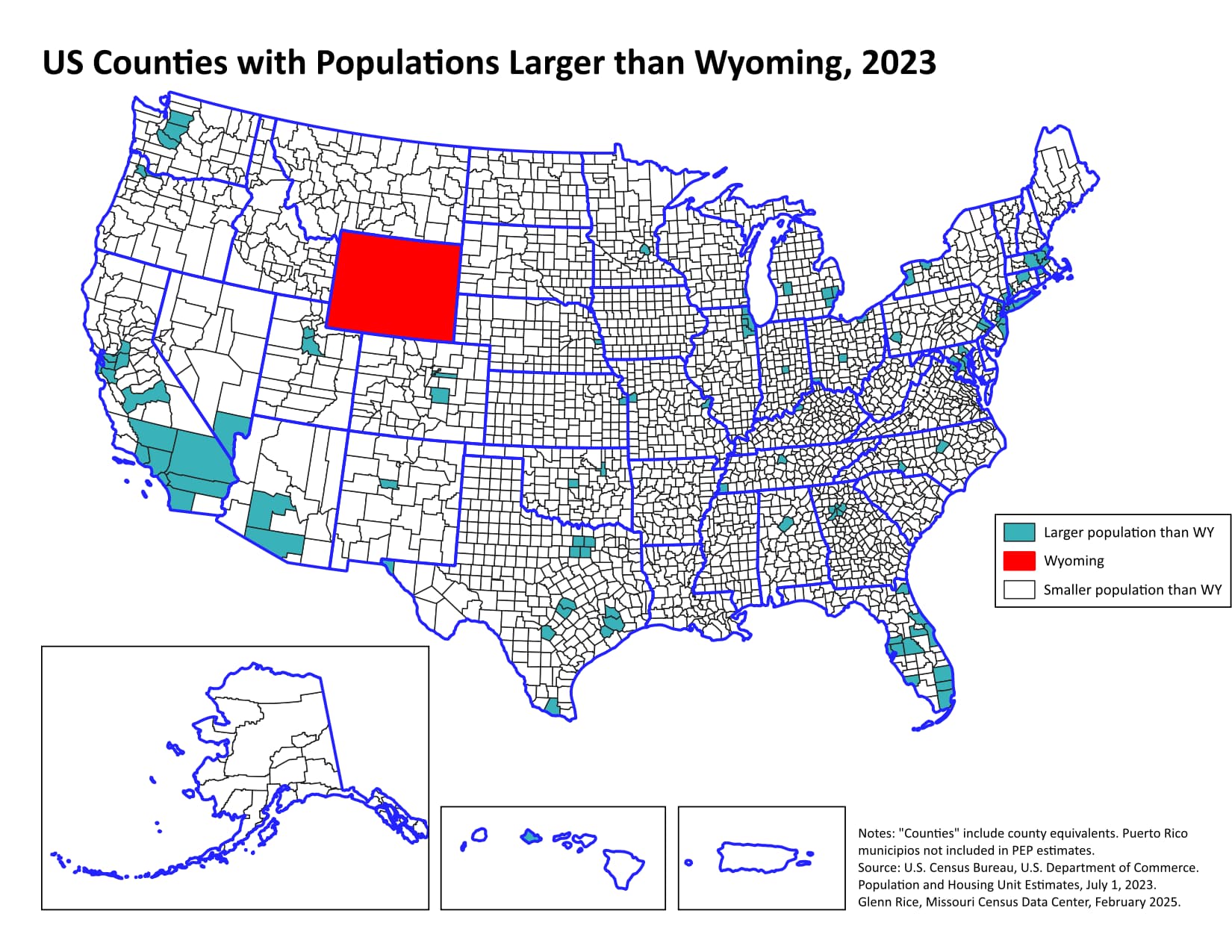
ETA it does add a number of smaller (but still large) cities like Atlanta, Kansas City, St. Louis, Denver, Indianapolis, Buffalo, etc.
14 Likes
Yeah, Fairfax County, VA is 1,141,878 and is part of the blue blob around DC. Fairfax City, however, has only 25,144 people.
You’re probably aware that VA has a number of “independent” cities that are governed separately from their surrounding counties of (usually) the same name. We Census nerds consider these to be county equivalents. Admin 2, in GIS terms.
11 Likes
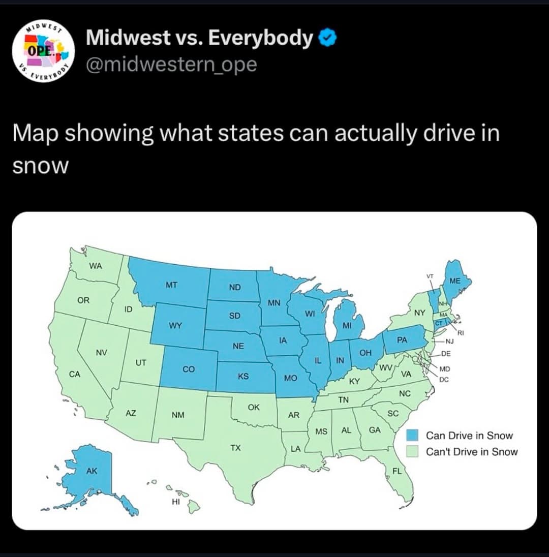
As someone who lives in WA, I can definitely confirm this. However, to be fair, most OR drivers can’t drive even under optimal conditions. If you’re ever in WA where drivers are already pretty bad, make sure you give anybody with OR plates a wide berth.
14 Likes
To also be fair, even in WI there seems to be a not insignificant number of drivers who forget how to drive in snow between the winter months.
12 Likes
what is this snow you speak of, and why would i drive on it…?
do i need special knowledge or skill to prepare for this driving?
15 Likes