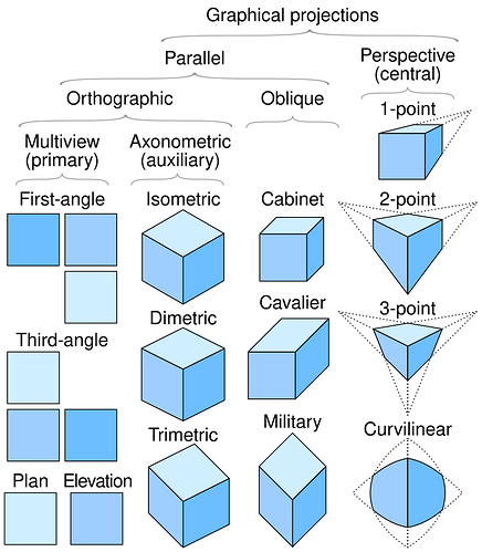
Oblique?
I mean, you are technically correct, and they would have known it at the time as well, but I suspect that they either didn’t care, or it was a term of art by then.
There are references in 1887 to “isometric view” maps being drawn up by the surveyor’s office, for example.
It’s also possible that a birds-eye view projection of a small feature might be an isometric view in the technical sense, and was extended to mean any map drawn from a point of view of above and in a direction other than straight down, if only by extension, especially if it’s meant as a decorative map rather than a working one.
To you it does.
But to a publisher who thinks he can sell more of them using a “scientific” name (or dodge another publisher’s trademark)?
One famous example of this technique is George Lawrence’s photo taken after the San Francisco earthquake:
That’s a pretty cool pic
Isn’t it? I have a copy of it in rotation as the background image on my desktop computer, and when it shows up every few weeks I always find it fascinating to look at.
From the link you provided:
a 49-pound camera raised 1000 feet above the bay with a train of Conyne kites
I feel like i need to know more


On a related note:
The modern version:
my kids and i built that rocket many years ago. we launched it several times out in Superstition Mountain Wilderness, east of Phoenix.
thing was - even then - finding anyone who still processed 110 film. finally got Tempe Camera to do it and the results were as shitty as one might imagine. lots of sky, some shaky pics of the tops of mesquite and saguaro, and one of the three of us looking up, shielding our eyes, searching for the 'chute.
good times!
don’t think we’d be mapping anything from those pics.
What are they calling Puerto Rico there? I can’t make it out.
There are different versions of the map at
Novae Insulae XVII Nova Tabula [First State!] - Barry Lawrence Ruderman Map Collection - Spotlight Exhibits and Novae Insulae XXVI Nova Tabula [Rare 2nd State of first map of the continent of America] - Barry Lawrence Ruderman Map Collection - Spotlight Exhibits
I think Puerto Rico is marked as “Sciana”, with which Stanford’s description concurs.
Thanks!
“ Some scholars suggest “Sciana” might be a misinterpretation of an earlier indigenous name for Puerto Rico, or it could refer to a smaller island near Hispaniola.”
I think the worst tourists in Britain are also the British.
Oooohhh…
Almost a decade ago I taped a key fob style camera to a rocket kiddo and I made. This looks like the deluxe version.
SA-WEET!
sweet video of the entire flight.
that’s the difference in the two ways - old and new. where you were able to attach a small fobcam to the outside of your craft, the 110 “camera” inside the Estes rocket was triggered by the ejection charge of the A series solid rocket motor that powered it. too short of ejection and you got pix of sky., too long and your pix were shaky treetops. just right - and don’t ask me what that was - and you get that after-apex shot of the ground below from up high.
really like your vid. reminds me of Hello Kitty’s ride on a high-altitude weather ballon that made the 'net rounds many years ago.

